The house to the far right, with the picnic table under the umbrella is the harbor master's house. They sell fresh fish and cooked fish dinners. There are 2 inns in town that also have restaurants.
On shore, here are the flowers and "left-overs" on the trail to the middle of "town"
A walk through town consists of the fish house, a small grocery, a couple of shops (one that also sells coffee!), a couple of art galleries, a pizza place that sells wine and beer, a new wash/fold that I didn't see, and the church.
The next day we hiked up the hill and across the island. First stop was the old lighthouse.
This lighthouse had a wonderful antique second order Fresnel lens that the Coast Guard took down in 1995 to replace with a more modern electric light. Then they DESTROYED lens!!!! Luke has a comment, but I can't put it here... There is a nice museum in the old keepers house.
The view of the town from the lighthouse. The hill behind the large building (The Island Inn) is actually a small island on the other side of the harbor. Latitudes is moored between the two islands.
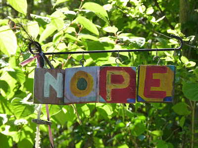
On the way up the hill, we came across a small gallery. I love her sign --- Nope, we aren't open.
But, move only 1 letter and they are OPEN! Look carefully.... very clever!
Finally at the cliffs on the other side of the island. View to the left
View to the right
View of two happy hikers
From Monhegan, we headed back to the mainland to Boothbay. This was pretty much a "work" stop. We got $19 worth of laundry done, groceries resupplied, $5 pizza lunch, and Luke visited the Friends of the Library used book/CD store for a couple of books. Once the necessities were taken care of, we took time to visit the lighthouse on Burnt Island.
Then a stop at the Maine Aquarium. This is a small, one room aquarium, but well done. The touch tank for sharks had 2 dog sharks. These rascals apparently like to be touched, and actually hold their heads out of water and "dance" in a circle to get petted.
And here is Henry, a 14 pound lobster. I played with the light on the picture so you can see him in his dark tank.
There was also a display of trash of the sea and how long it takes for trash thrown into the ocean to disintegrate - here are some of the disheartening numbers -
milk carton - 400 years
Styrofoam cup - never
cigarette - 5 years
glass bottle - 1000 to 1 million years
ziplock bags - 300 years
a simple paper towel? a month!
From Boothbay to Port Clyde. We again sailed around Eastern Egg Rock Island, looking for puffins, but saw none this time. I did take a picture of the huts where the volunteers stay to count puffins. To my surprise, we realized that we caught a bald eagle sitting on a rock to the left.
The small dock area is the "town" or Port Clyde. These few buildings are a restaurant, grocery/wine, coffee house, and ferry terminal. An ice cream store and kayak rental store can't be seen. Also, in the second floor of the grocery is a very nice art gallery with works of the Wythe family for sale.
A walk down the road towards the lighthouse shows a different view of town.
We left this morning for Rockland. We had high hopes and encroaching fog... Here is the Marshall Island lighthouse, at Port Clyde with the fog starting to roll in. BTW, this is the lighthouse used in the Forrest Gump movie when he ran all the way to the end of a lighthouse.
The fog just got worse. We ran relatively close to at least 5 oncoming boats as we proceeded up Mussel Ridge channel, a popular approach into the Penobscot bay from the west. We "saw" them on radar at a mile or more distance, and then they'd emerge from the fog surprisingly close - 500 to 1000 ft away. WE were using our fog horn, but heard only one other horn during our passage. We did make it most of the way, but with 8 miles left to Rockland, we gave up and anchored between Dix and High Islands again. The plan is to go to Rockland later when the fog lifts, but it's just getting thicker...can't even see the islands or one of the 3 boats anchored near us. I am glad we're here now!


No comments:
Post a Comment