Tuesday, July 24, 2018

Cross Island (submarine communications!), Jonesport (amazing model RR!), and puffins, puffins, puffins (puffins!)

We found a new place to explore - Cross Island.  Luke has wanted to go there since last year when boating buddy Dick told him about it.  A mere 17 miles from Canada (directly eastward, Grand Manan Island), Cross is the nearest we can get to an amazing piece of Cold War history. These are the vertical support towers, nearly 1000 ft high, of the Very Low Frequency (VLF) radio array used to communicate with submerged submarines.  For the techies - it transmits at 24 kHz with an output power of nearly 2 mega watts, apparently one of the strongest radio transmitters in the world. For some details, please see https://en.wikipedia.org/wiki/VLF_Transmitter_Cutler   I'm sure this is now replaced with satellite communications, but still remains as an alternate.


The towers, with their red flashing lights present an eerie backdrop to the threatening grey cloud bank at dusk.


On our way to the island, we encountered a relatively new Maine business, salmon farming.  There are 2 companies here, each with 3 or 4 of these large pens.  For size reference, look at the 2 orange figures on the left side - they are men working on the netting that covers the pens.


Cross island is a MITA property - the Maine Island Trail Association. That means we can hike on the island.  The old dock leaves something to be desired...a dry landing space at high tide.  It was almost high tide when we got there and we barely made it to the higher dock.   The dinghy was tied to float, and float she did - right over the submerged dock.


Fat, sweet-tart blueberries were everywhere!


The only remaining trail on the island that we found lead past on old (and still used) outhouse to a rocky beach.


We did find one more path, but it ended quickly at an unkept (and unsafe) bridge over a creek.


After the tide went down, we got back in the dinghy cruised around part of the island on water. The other end of Cross.


And a nearby island.  Beautiful, beautiful Maine!


Next to another favorite place while we are down east, Jonesport.  We took a raft mooring at Jonesport Shipyard, in the harbor with all of the lobster boats.


This old, well restored home graces the town dock.  Some of Maine's wildflowers fill the yard.  Remember this house - she's going to come up again in the next picture!


The kind boatyard owners lent us their car to go to Michas (the nearest larger town) for groceries.  On the way back, we stopped in at a sign that says "Maine Central Model Railroad".  This amazing HO gauge (1/87 th scale) model railroad is in a shed outside of the home, the "train yard' being about 30 x 40 feet .  This is only about 1/4 of the set up. It is so filled up that you have to wander through narrow aisles to  see it all. See  the red Victorian house in the bottom left? That is the house above.  Every building in this model was built by the owners, Helen and Buz.  It took them 20 years to complete this set up.


A town wharf.


Buz died 6 years ago, but Helen still shows his favorite "joke" in the display....a hunter "taking a crap" while a bear approaches and his rifle  (the little red handle to the left) is jusssst out of reach.


Here is Helen at the controls, running the tooting, puffing trains for us.


This is all free, just asking for a small donation.  Sadly, the future of this wonderful model RR is in question.  Helen is 84, and admits she can't keep it up much longer.  There isn't a good home waiting for the wonderful work they have done.

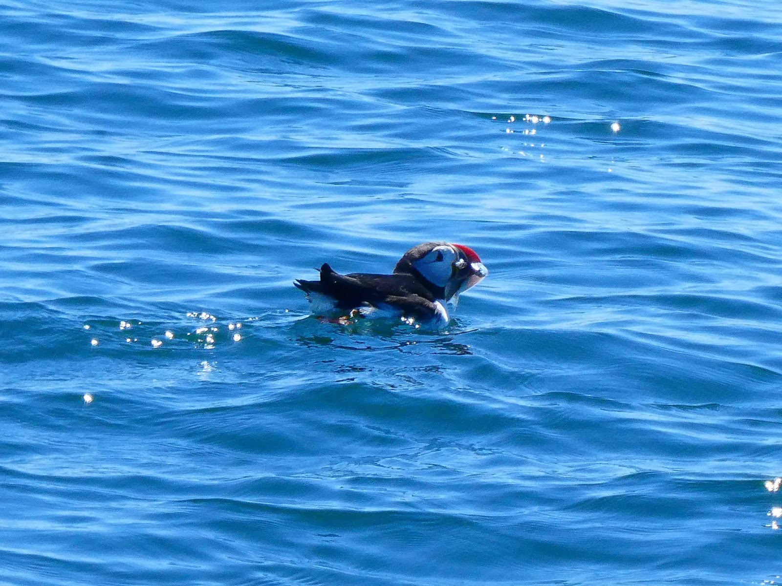
We always knew Maine had fog, but boy, has she lived up to it this year!  fog,fog, fog.  As soon as we got an OK (not great) day to make the 9 hour trip from Jonesport to Acadia, we left.  Our big excitement en route was to again pass the Petite Manan lighthouse with puffins.  This time we really saw them!  What more can I say... puffins, puffins, puffins!!!

Puffins with fish for the babies!


Puffins joyously bathing


And puffins just floating with the tide.


Next blog, Acadia National Park.

Friday, July 20, 2018

Headed Down East


OK, this is a long one because we’re in those areas “down east” where the internet is sparse.  There are lots of pictures, but I promise, very few words 😊

Another day in Maine, another lighthouse!  This one is on Mark Island, just entering the throughfare to Stonington.


Stonington is a nice place to visit – they have ice cream, coffee, a little grocery store, some shops, a tiny museum, and a couple of places to eat.  But mostly they have lobstering.  This means they have lots and lots of lobster boats and even more lobster floats in the water.  It can be challenging to navigate the waters here. 

Here are a few of the almost 200 lobster boats moored here.  Stonington has the distinction of being the biggest lobster town in Maine.  Last year, they pulled in over $68M in lobsters!


This is the dock for one of the several lobster co-ops in town.  The lobstermen use small dinghys to get to their boats that are on moorings in the harbor.  Most of the men men are back already, so the dinghy dock is beginning to fill up.


As in all of Maine, the tides are extreme.  This low tide has the boat dock sitting on mud.


And here we are in Stonington!  Do you think they know we are boaters/tourists???


Stonington used to be a major source of carved granite, worldwide.  Skilled Italian and Irish granite carvers migrated here to work. The granite mines are still on a nearby island.  Interesting, 5 men still work at the granite business.  They cut and carve the granite to order.  This high crane meets you as you enter the channel to Stonington.


Tired of civilization, we decided to head Down East next, along the northern Maine coast which is dramatically beautiful and less inhabited.  We couldn’t make it in one day, plus we needed to fill up the diesel and our water tanks.  No convenient diesel or water to be had up here.  We headed to SW Harbor for the diesel and water, and then anchored for the night in the Cranberry Isles.  Here is the Bass Harbor lighthouse as we passed her.


Little Cranberry Island is just that – small.  The town has a lobster pound, museum, church, and a place to buy lobsters.  That is about it, but we enjoy going ashore.  It was too late by the time we got there this time.


We watched a raft of little black and white Guillemonts.  According to Wikipedia, these little 2 pound fellows can fly 61 miles from the nest to find food for their chicks.  And they can dive 300 feet to find food!


Here is a good close-up of one


We left at 7 the next morning to finish our trip. The Petit Manan island and lighthouse are along our route.


A whale watching boat was stopped so Luke hailed him to ask if there were any whales?  Nope, but puffins nest here… yes, they do!


Smoke saw them, too.


There are observation boxes on the island.  Look carefully on the flat rocks below the white box and you’ll see puffins nesting.  We didn’t see them until we looked at our picture.


Almost at our destination, Mistake Island!  Here is the Mistake Island lighthouse,  the Moose Peak Lighthouse, from the water.


The water in the channel beside the lighthouse was high when we arrived.


HERE is what low tide looks like!  


This is the same view, toward the lighthouse.


Our dinghy is sitting aground, facing the anchorage and Latitudes.  She was well afloat when we left her.  You can see her long anchor line on the rocks.  This shed is the old Coast Guard shed and is the beginning of the boardwalk to the lighthouse.


The next morning we went ashore for a walk.  Wild iris bloomed against the old shed.


Here’s the boardwalk and Luke!


The view as you near the lighthouse is magnificent.  The morning fog had burned away at Mistake, but was still drifting about on the deep water.


The boardwalk goes through tall shady bushes and opens into a field, full of spring wildflowers.  The building on the right has the solar panels that maintain the unmanned lighthouse.


Luke got this spectacular picture of the lighthouse and its reflection in the small pond.


By the time we got to the lighthouse, a drifting fog surrounded it.


We startled this eagle.  He flew past us and waited patiently on this tree until we left.


Here is the view after we turned around and headed back to the dinghy.


The next morning was DEFINITELY foggy – heavy fog surrounded us shortly after Luke took this picture.


After the fog lifted enough, we braved the next 10 miles to go to Roque.  Roque is an archipelago of several islands.  We love to anchor here and walk the mile long white beach.  We didn’t get much of that done – fog came rolling in again.  Fortunately, we were able to buy a couple of lobsters directly from a lobsterman before we left Mistake, so we had lobster for dinner!  And yes, it is that cold here.  Dense drippy fog, rain showers, a high of 57….and  the boat is sitting in 50 degree water.  Our living space is mostly beneath the water line.  burr.