Thursday, August 30, 2012

Who knew red dirt could look so good!!!??

En route again, this time 250 miles southward, leaving the 8000 ft altitude forest to NE Utah, to the great circle of national parks.


As we descended the heights, we trundled along a Utah Federal Highway, something close akin to a "secondary road".  But it was a scenic and education road.  Did you know that this is where your oil comes from?  Lonely oil pumps in the middle of no-where?


We stopped at a turn-out along the road for lunch.  Smokey, aka Brown-Princess-Chipmunk-Hunter, really wanted to go hunting while we ate.


Back on flat land, but the promise of mountainous national parks kept our interest peaked.


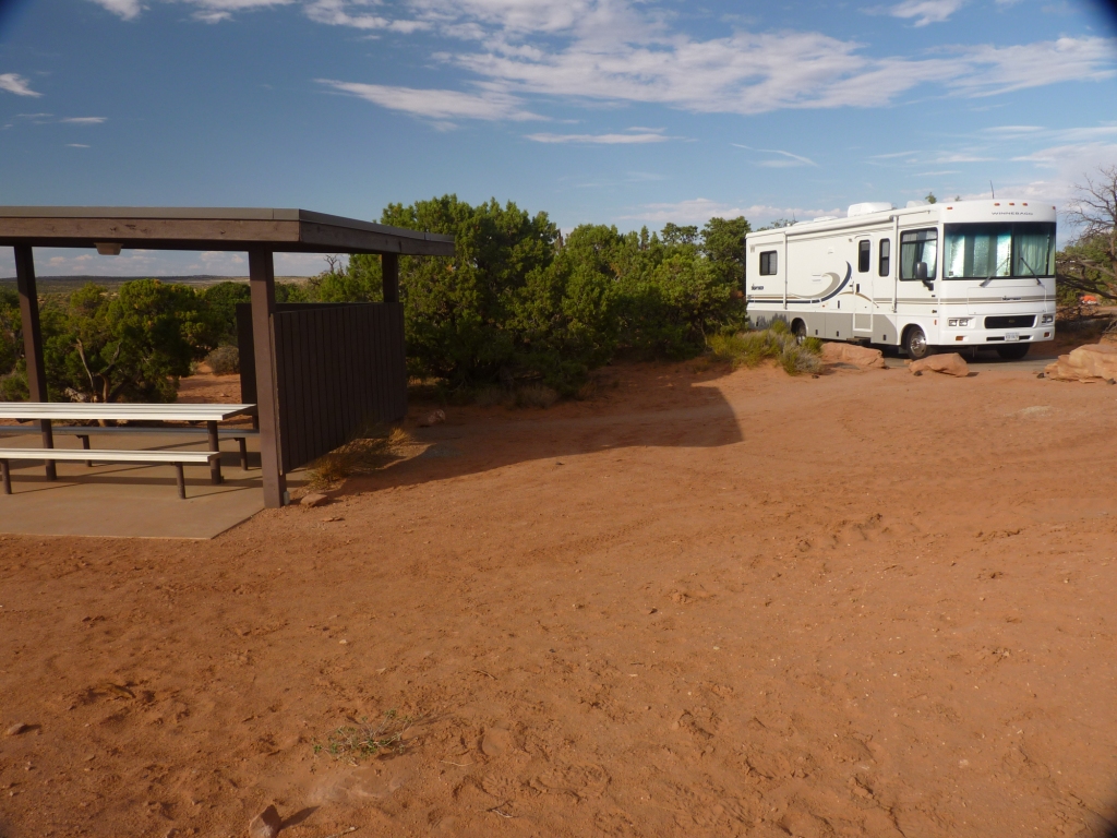
Finally!!!  Up a few thousand feet and here we are, Canyonland National Park country!!!!  This is just one view at the Visitor Center, at the entrance to our camp site at Dead Horse Point State Park (more on that name later in the blog).


We had dire expectations of the campground, based on the treeless, hot (95 at the gas station), red clay environment.  Pleasantly surprised - yes, it's still hot and dusty red clay.  But we are in a campground of only 20 sites, clean toilets, and a shaded picnic area.  There is no water in the area, so we had to be sure we came in with a full tank.  But we have electricity, a blessing in this heat.  Last night, by 10:30, we turned it off, opened windows, and it was perfect.


This morning, EARLY TO AVOID HEAT, we drove to the point of Dead Horse Point State Park.  It was a little hazy, so these aren't perfect pictures, but I'm sure we'll try again.   Our first views of amazing Canyonlands National Park.


Look carefully and you'll see the Green River,tributary to the Colorado River, flowing and twisting through the canyon land.


On our short drive to the extreme south end of the park, we saw evidence of mixed weather, so common here. It's a combination of  sun beams shining through the clouds and rain pouring.


The Grand View hiking  trail is ...well, I am beyond words.  However, I am VERY PROUD to say that I walked the entire 2 mile (round trip) trail. Slowly, but without my brace or cast.  I am healing!!!
The trail runs along the rim of the canyon.


It's a steep drop off.... no, I'm not afraid of heights, and no, I didn't get any closer!!!


The trail end is at the far point of the first butte.  Here is a view from the starting of the trail.


The view from the trail end is the other side of the canyon.  wow.

 
The sun came out and really showed how red the rocks are.


Millions of years of flowing and ebbing oceans in the canyons have carved wonderous canyons within the canyon.


Back from the Grand View,we saw Candlestick.


Next, a walk to see our first arch,  Mesa Arch.


Boy, does it sit on the edge of the canyon wall!  That dark overhead is the bottom of the arch.


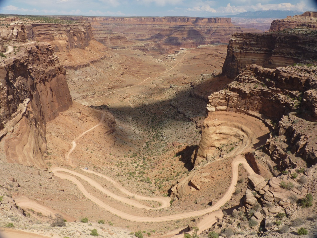
Last, a drive across "The Neck".  Canyonlands land is sort of like a Y.  At one point there is a narrow (49 ft) wide natural bridge that connects the bottom of the Y with the rest of it.  This natural bridge was used by cowboys and settlers to keep cattle and horses corralled with only a bit of fencing at the Neck.  Horse wranglers drove wild horses into this neck, selected and sold the best, and left the remaining horses to die of thirst, thousands of feet from the nearest water.  Therefore, the name --- Dead Horse Point.  You can see both sides of the canyon, but not the narrow neck that connects them.


Back at the RV before 4, trying miss some of the heat of the day, The plan for tomorrow is to drive to Mesa Verde.  More photos!!!

Red Canyon, dinosaurs, and petroglyphs

We headed toward Flaming Gorge, more exactly the Red Canyon that overlooks the river.  First, the usual cows in the road.

Then turkeys.


Then the fabulous view of the Red Canyon.  The morning was slightly overcast, a shame because these walls can glow red in the sun.  A look up-stream, down the deep canyon.


Then down-stream.  Want proof these walls are high?  That tiny white spec is a good sized motor boat and it's wake.


Next we took a 16 mile detour to the Sheep Creek Geological Area.


Amazing formations.


Determined to see it all, next we drove to the Dinosaur National Monument.   This is an area full of dinosaur bones, dating back to the Late-Jurassic period,  about 147 - 155 million years ago.  The region is full of bones of all 4 major types of dinosaurs, plus 250 species of plants, and clams, snails, crayfish, insects, salamanders, frogs, lizards, turtles, crocodiles, and small mammals.   Although many of the bones have been excavated, a complete wall of rock, still full of fossils, has been designated a national site and saved for future generations.  Some of the dinosaurs are more or less complete.


There are birds.


And jumbles of bones.  Many of these leg bones are much larger than I am tall.


Further down the road in the park is a large wall of petroglyphs.  Here is one little group of natives and animals.


The most famous is a 6 foot long lizard.


He is actually joined by several more, smaller lizards.   And Luke.  The plaques ask that you please not touch the ancient petroglyphs, but they are simply unprotected.  No, of course we did not touch them.


Last, a local flutist.


We ended the long day with a great Mexican dinner and a little Wal-Mart'ing.  Back to the RV at 10:30, we were up early today to drive the 250 miles south to  Arches National Park.  We'll start exploring Arches, Canyonlands, Needles, and maybe Mesa Verde from our little red-clay camp site in the Dead Horse Point State Park.  More tomorrow!

Tuesday, August 28, 2012

GRAND Teton National Park!


Off to Jackson and Grand Teton National Park! Home of the MOST magnificent mountain range!  Just look ----  see the magnificent mountain range???


 No, we didn’t either…. Smoke.  Not the sweet furry kind, but the kind from the endless fires in Montana and Idaho.  We were so disappointed.  BUT – the winds changed and yesterday and today we saw the true Teton Mt. Range..  MAGNIFICENT!!!!


Later we took the boat ride across Jenny Lake to make the gentle climb up to Inspiration Point and the Hidden Falls.  It was still so smoky that the mountain was just hazy.

 
Lisa, Mat, and Simon accompanied us to the Grand Tetons.  Here is the group, in front of the Hidden Waterfall across Jenny Lake.


And here is the waterfall.


The water really rushed downstream.


As the smoke cleared more during the day we could see the beautiful mountain range.


We did see moose in the park!  Finally!  Of course, he had his butt towards us….


S’mores over the campfire with Simon.


Sunday we drove to Jackson Hole, a tourist town if I’ve ever seen one.  A GREAT tourist town! Wooden sidewalks, wonderful shops, bars with real leather saddles and wool blankets on the bar stools.


 Here is the entrance to the town park.  Elk loose their antlers every year.  The local Boy Scouts gather them to sell.  These entrances are made with dropped antlers.


This statue is the WY state “symbol”, found on everything.  Nice to see the real thing. 

 
Off for Flaming Gorge, UT,  on Monday, leaving the family behind to return to Co in time for Simon to start school.  We miss them.  Down from the high prairie we drove, into the canyons.


The 300 mile trip southwards to Flaming Gorge National Recreation Area was beautiful.  We missed (mostly) rain squalls.  There was a nice one that caught us – just enough to wash the dust off of the RV and car!
 
We did climb again and see the high prairies (8000 ft up).


On Tuesday we’ll explore the area.  Right now we are tucked in an almost deserted campground.  At 8000 feet elevation, our wooded campground is filled with aspens and lodgepole pines.  Quiet and beautiful. 
 
Smoke went for 3 long walks with us, all in the name of  searching for chipmunks to chase.  None to be found….  She hunts while wearing her harness and on a leash.  Actually, she has climbed trees a couple of times while in pursuit.  A very good girl!